

✔ Beste opleider op het gebied van Data en IT
✔ Klantbeoordeling 9,8/10 ★★★★★
✔ Focus op persoonlijke aandacht
6 september, 2019
“Profit from Data.”
Geronimo.AI is founded in November 2018 by four former students of the TU Delft and aims to apply Artificial Intelligence (AI) in an accessible way to companies and government. Our tailor-made solutions focus on everyday challenges and can be divided into two domains. Geospatial Machine Learning analyses data which is linked to geographical locations, including aerial images and satellite data. Natural Language Processing helps in automating processes in which text is involved. In this blog, one of our projects will be discussed. To check out our other projects, check Geronimo.AI.
The Rijksvastgoedbedrijf (RVB), part of the Ministry of Internal Affairs, owns 45.000 hectares of agricultural land. This land has to be cropped according to a crop rotation plan to prevent soil depletion and ensure durability. However, the RVB is missing tools to gain insight in the actual use of the land to determine whether the plan is being complied with.
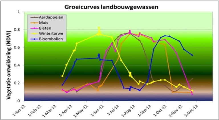
Our solution classifies all the crops grown on leased lands using a data driven approach. Crops have a different absorption spectra throughout their lifetime, they might start off green, get darker, turn yellow around their bloom and then slowly fade towards brown. This temporal absorption and reflection can be expressed in growth curves which plot the Normalized Difference Vegation Index (NVDI) over time. NDVI values can be calculated by taking red and near infrared light measurements from satellites, specifically Sentinel 2. This results in growth curves corresponding to different crops, as can be seen in Figure 1.
Figure 1 can be used to perform classification to all the outputs required by the stakeholders (lilies, onions, carrots, etc.). Furthermore, these classifications can be made using a data driven approach, i.e. to use a model to classify crops based on their growth curves. In order to use supervised classification methods, ground-truth labels are required to train a model. This ground truth data is taken from the Basisregistratie Gewaspercelen (BRP). The BRP is an open data set that contains parcels with labeled crops for each agricultural field in the Netherlands.
This insight in the tradeoff between performance and time of classification was essential for a consumer fit product: The end user needs to act on the results of the classification. However, by the end of September all proof of the correctness of the classification will be vanished because farmers will have started ploughing their lands. Therefore, we agreed on a number of classifying moments with increasing performance.
We are looking into using Sentinel-1 RADAR images to expand the input of the model. This should reduce the confusion between crops with similar growth curves, such as corn and potatoes. Check out Geronimo.AI to keep up to date!
“Uitstekende cursus om mee te beginnen. Het werd goed uitgelegd, een fijn tempo en een goede verhouding tussen zelf dingen kunnen doen en de uitleg.”
Ger van Leusen – Chemisch Analist bij Vitens